ยาน LRO สำรวจดวงจันทร์
ยาน LRO สำรวจดวงจันทร์
Images from the ภาพจากยาน
Lunar Reconnaissance Orbiter
Lunar Reconnaissance Orbiter
source : http://www.boston.com/bigpicture/2010/01
/images_from_the_lunar_reconnai.html
NASA's Lunar Reconnaissance Orbiter (LRO) was launched in June, 2009, and is currently orbiting the Moon around its poles at a low altitude of just 50 kilometers (31 miles). The primary objective of the LRO is to prepare for future lunar exploration, scouting for safe and compelling landing sites, potential resources (like water ice) and more. The high-quality imagery used in the mapping of the lunar surface is unprecedented, and a few early images have included detailed overviews of the landing sites of several Apollo missions, some 40 years after they took place. LRO is now on a one year mission, with possible extensions up to five years. Collected here are several recent LRO images, and a few then-and-now comparisons of Apollo landing sites.
ยานสำรวจดวงจันทร์ขององค์การบริหารการบินและอวกาศแห่งชาติอเมริกา (นาซา) ยานลูนาร์ รีคอนเนสซอง ออร์บิตเตอร์ (LRO) ถูกปล่อยสู่อวกาศในเดือนมิถุนายน 2009 และตอนนี้ ( ยานนี้จะมีภารกิจสำรวจเป็นเวล่า 5 ปี) ก็กำลังโคจรรอบดวงจันทร์ บริเวณทั้งสองขั้วของดวงจันทร์ ในระดับต่ำ แค่ 50 กม. (31 ไมล์) จุดประสงค์ของการส่งยานนี้ไปโคจรรอบดวงจันทร์ ก็เพื่อทำการลาดตระเวน (Reconnaissance) ก่อนการสำรวจจริงจังในวันข้างหน้า เพื่อหาจุดที่ปลอดภัยในการร่อนลง และมีทรัพยากร เช่น น้ำแข็ง หรือไม่ ..นี่เป็นภาพส่วนหนึ่งที่ได้จากยานนี้
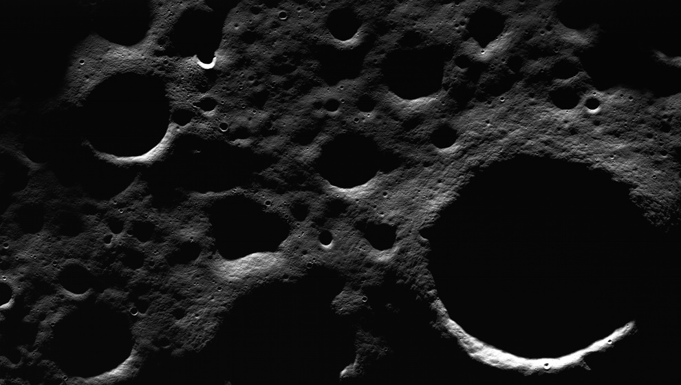
Near the lunar north pole, many craters on the floor of Peary crater experience permanent shadow inside, and some have permanent illumination on the higher crater rims. Peary is a key exploration site for future astronauts due its proximity to potential resources. Image height is 9 km (5.5 mi). Image acquired July 11th, 2009. More(NASA/GSFC/Arizona State University)
ที่ใกล้ขั้วเหนือของดวงจันทร์ มีหลุมอุกกาบาตมาก บนอาณาบริเวณที่เรียกว่า พื้นเพียรี หลุมเหล่านี้จะมองไม่เห็นเพราะมีเงาบัง ขณะที่ส่วนขอบหลุมก็จะสว่างหน่อย การสำรวจพื้นเพียรีนี้ เป็นกุญแจดอกสำคัญสำหรับนักบินอวกาศในอนาคต
ที่ใกล้ขั้วเหนือของดวงจันทร์ มีหลุมอุกกาบาตมาก บนอาณาบริเวณที่เรียกว่า พื้นเพียรี หลุมเหล่านี้จะมองไม่เห็นเพราะมีเงาบัง ขณะที่ส่วนขอบหลุมก็จะสว่างหน่อย การสำรวจพื้นเพียรีนี้ เป็นกุญแจดอกสำคัญสำหรับนักบินอวกาศในอนาคต
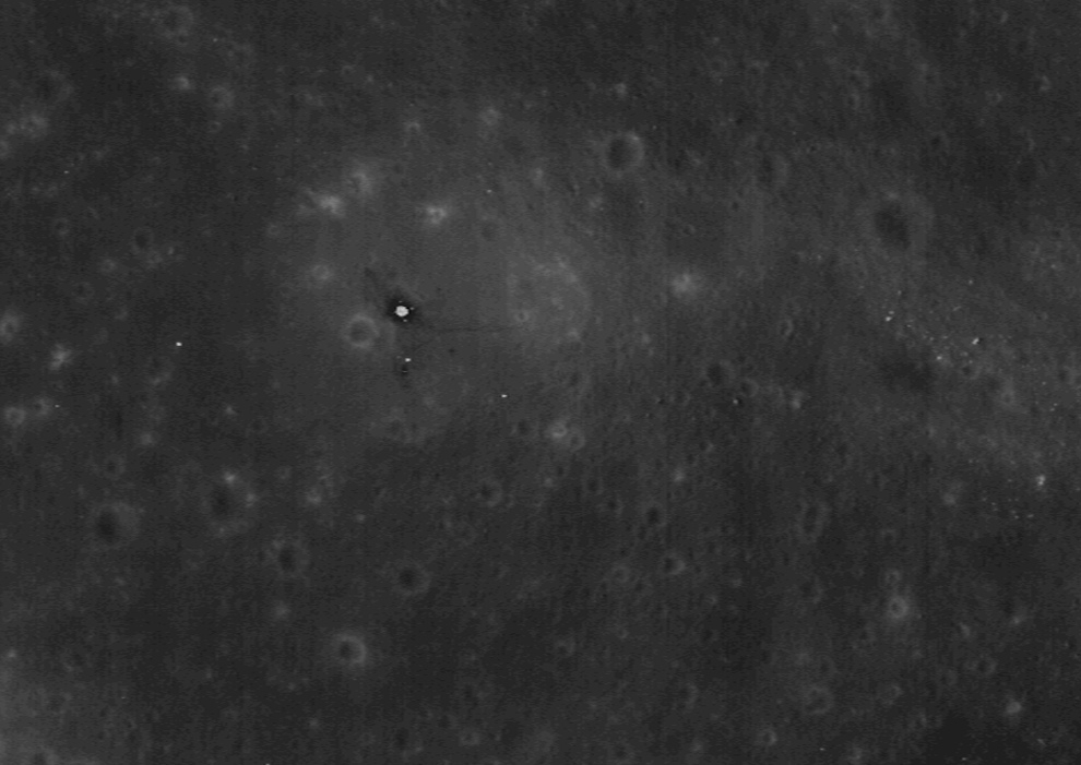
The site of the landing of Apollo 11, named "Tranquility Base", seen by LRO as it passed overhead on October 1st, 2009. On July 20th, 1969, NASA astronauts Neil Armstrong, and Edwin "Buzz" Aldrin landed on the surface of the moon for the first time, spending less than a day there, and only 2.5 hours exploring on foot. The large bright spot at center is the Lunar Module (LM) descent stage, its four foot pads barely visible. The dark halo around the LM is from the astronauts' heavy foot traffic. Several experiments can also be seen, and a trail leading to the right left by Armstrong as he trekked to Little West crater. More (NASA/GSFC/Arizona State University) #
Tranquility Base เป็นจุดที่ยานสำรวจพื้นผิวดวงจันทร์ ลูนาร์ โมดุล อีเกิล ของโครงการอพอลโล-11 เคยมาลงจอดที่นี่ เมื่อปี 20 กรกฎาคม 1969 (40 กว่าปีก่อน) โดยนักบินอวกาศ นีล อาร์มสตรอง และ บัสซ์ แอนดริน ทั้งสองท่าน ใช้เวลา 2 ชั่วโมงครึ่ง จุดสว่างตรงกลาง เป็นขาของยานลูนาร์โมดุลอีเกิลทิ้งไว้ ยังเห็นแผ่นรองขาตั้งยานได้ลางๆ ส่วนเงาที่อยู่รอบๆ ขาตั้งยาน ก็เป็นรอยเท้าที่ย่ำไปย่ำมาของนักบินอวกาศ การทดลองต่างๆ ของนักบินอวกาศยังมีให้เห็น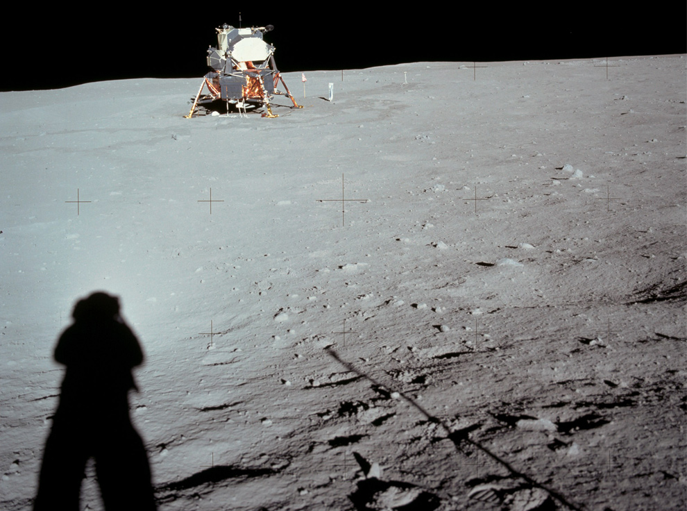
On July 20th, 1969, NASA astronaut Neil Armstrong looks back at the Apollo 11 Lunar Module from Little West crater - oriented to the previous overhead photo, Armstrong would be standing in the center, looking to the left. (NASA) #
20/07/69 นักบินอวกาศ นีล อาร์มสตรอง หันกลับมามองยานลูนาร์โมดุล (ยานนี้จะเรียกอีกชื่อว่า ยานอีเกิล หรือนกอินทรี ซึ่งก็คือสหรัฐอเมริกานั่นเอง-ผู้แปล) อาร์มสตรอง จากปล่องภูเขาไฟขนาดย่อม เขายืนตรงกลางและเหลียวไปทางขวา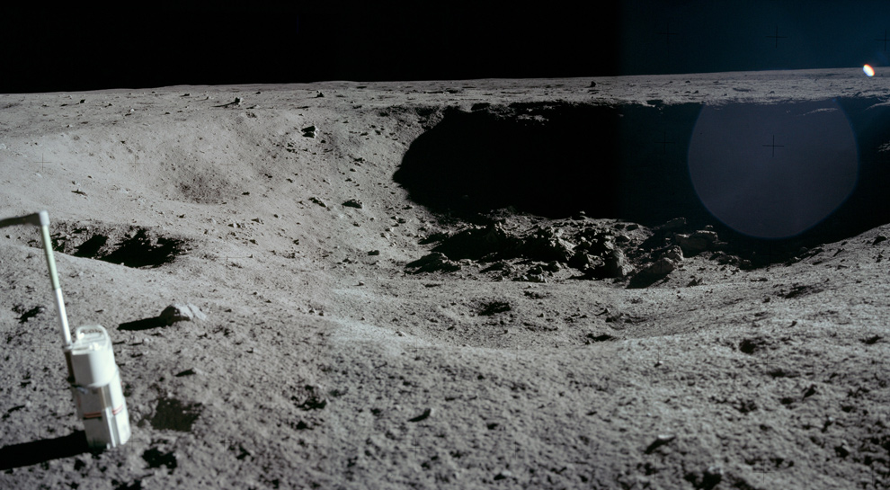
Looking the opposite direction as the previous photo, also on July 20th, 1969, NASA astronaut Neil Armstrong snapped this panorama of an experiment placed near Little West crater. (NASA) #
มองทิศตรงข้ามกับรูปที่แล้ว จากภาพพาโนรามา จะเห็นเครื่องมือทดลองของอพอลโล-11 ตั้งแต่ปี 1969 (45 ปีมาแล้ว) ก็ยังอยู่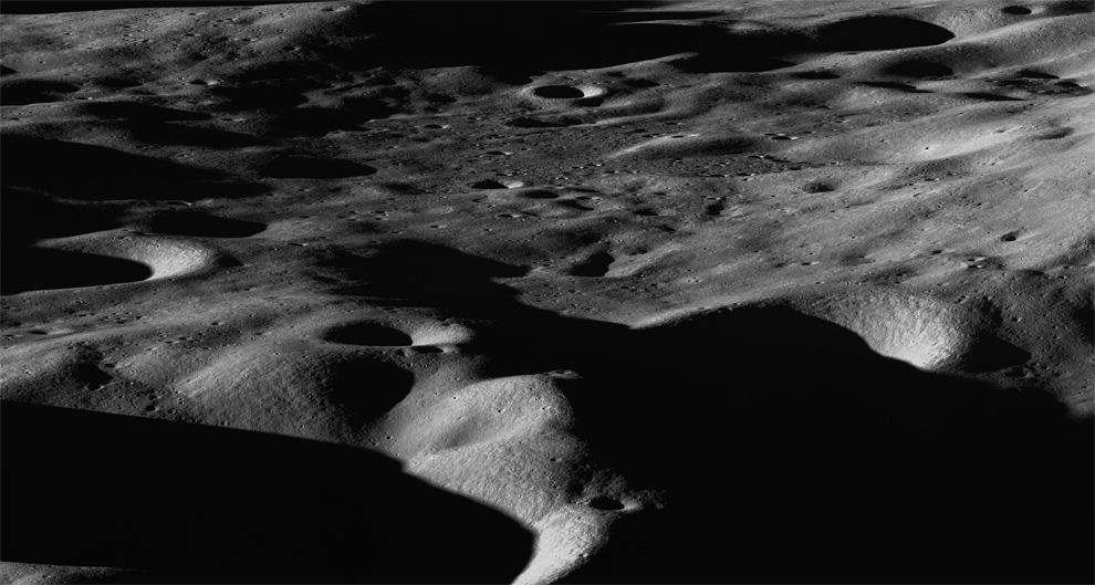
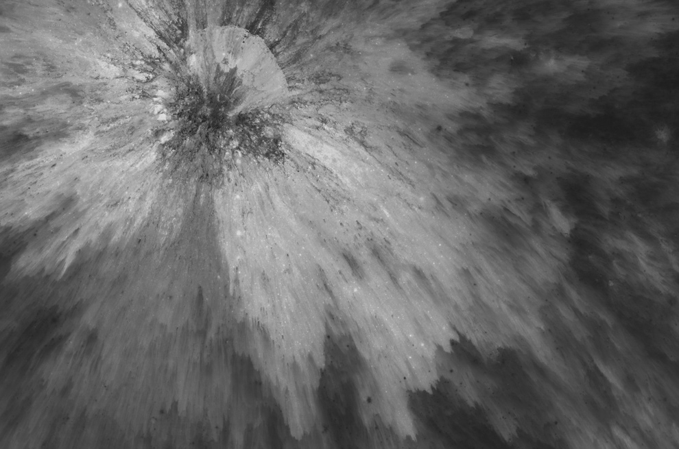
Two and a half days after NASA's earlier LCROSS experiment impacted the lunar surface searching for water, the LRO spacecraft slewed towards Cabeus crater near the Moon's south pole, to acquire an overview image of a portion of the northern rim from the southwest on October 11th, 2009. The distance from left to right is about 60 km (37 mi) and from foreground to background in the center is about 50 km (31 mi). The LCROSS impact was just off the bottom center of the panorama.More (NASA/GSFC/Arizona State University) #
บริเวณใกล้ขั้วใต้ของดวงจันทร์ ไปสำรวจดูว่าจะมีน้ำแข็งอยู่หรือไม่
The Apollo 12 landing site in Oceanus Procellarum, as imaged from the LRO mapping orbit on October 5th, 2009. On November 19, 1969, NASA astronauts Pete Conrad and Alan Bean landed on the Moon, setting their Lunar Module (center) down within walking distance of NASA's Surveyor 3 lunar lander probe. Surveyor 3 had landed two years earlier in the dark smudge at lower right. The tracks leading to the upper left end at a large package of experiments left there called the Apollo Lunar Surface Experiments Package, or ALSEP. More (NASA/GSFC/Arizona State University) #
เป็นจุดที่ยานสำรวจของ โครงการอพอลโล-12 ลงจอด เป็นบริเวณที่คล้ายกับทะเล 19 พฤศจิกายน 1969 นักบินอวกาศขององค์การนาซา พีท คอนราด และ อลัน บีน ได้ลงไปสำรวจดวงจันทร์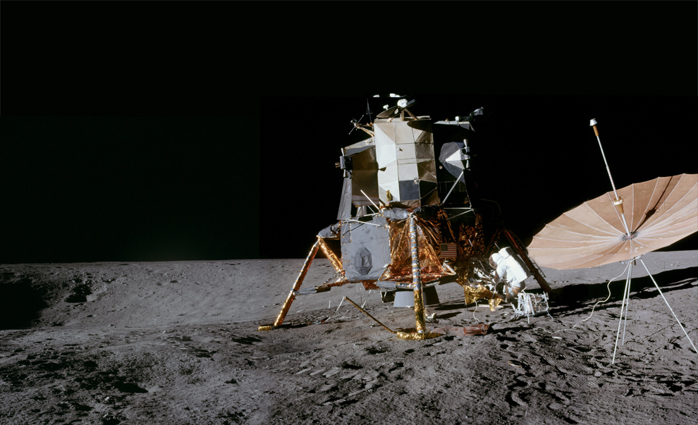
On November 19, 1969, astronaut Alan Bean captured this panorama of the Apollo 12 landing site, with Pete Conrad attending to the LM, and Surveyor crater to the left. Oriented to the previous overhead photo, this would be looking down and to the right from top center. (NASA) #
การลงจอดของยานสำรวจดวงจันทร์ โครงการอพอลโล-12 วันที่ 19 พฤศจิกายน 1969
เขียนโดย Unknown @ 04:21
0 ความคิดเห็น
![]()

0 ความคิดเห็น:
แสดงความคิดเห็น
สมัครสมาชิก ส่งความคิดเห็น [Atom]
<< หน้าแรก